Political map of the world states and their capital. "Modern political map of the world
Political map of the world is a geographical map reflecting the countries of the world, their form of government and government structure. The political map reflects the main political and geographical changes: the formation of new independent states, changes in their status, mergers and divisions of states, loss or acquisition of sovereignty, changes in the area of states, replacement of their capitals, changes in the names of states and capitals, changes in forms of government, etc. .
In a broad sense, the political map of the world is not only the state borders of countries plotted on a cartographic basis. It contains information about the history of the formation of political systems and states, about the relationship between states in the modern world, about the uniqueness of regions and countries in their political structure, about the influence of the location of countries on their political structure and economic development.
At the same time, the political map of the world is a historical category, since it reflects all changes in the political structure and borders of states that occur as a result of various historical events.
Colorful political map of the world in English

All the changes that have arisen on the political map over the long history of its formation are of a different nature. Among them, a distinction is made between quantitative and qualitative changes. Quantitative ones include: annexation of newly discovered lands; territorial gains or losses during wars; unification or disintegration of states; concessions or exchanges between countries of land areas. Other changes are qualitative. They consist in the historical change of socio-economic formations; the country's acquisition of political sovereignty; introduction of new forms of government; the formation of interstate political unions, the appearance and disappearance of “hot spots” on the planet. Often quantitative changes are accompanied by qualitative ones. Recent events in the world show that quantitative shifts on the political map are increasingly giving way to qualitative ones, and this leads to the understanding that instead of war - the usual means of resolving interstate disputes - the path of dialogues, peaceful resolution of territorial disputes and international conflicts comes to the fore.
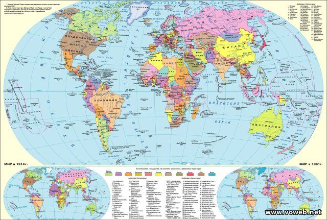
Political map of the world before the collapse of the USSR in Russian

Large detailed political map of the world in Russian

Political map of the world 2012

Political map of the world with real proportions of state areas

Political map of the world in Ukrainian

Large political map of the world

Political map of the world (Russian)

Map of dependent territories of the world

Very large and detailed political map of the world - Very large and detailed political map of the world

Old school, nostalgic political map of the world

Political World Map in English - Political World Map English


Political world map (relief) - Wikiwand Political world map (relief)

Political / Physical Map of the World

Political World Map - Political World Map

Political map of the Earth

Political map of the world in Russian - Political World Map

Political World Map - Political World Map

Political World Map - Political World Map

According to experts, in the near future the political map of the world will undergo major changes. The trend toward an increase in the number of states based on ethnic principles continues. At the same time, state borders that do not correspond to the nations living within them will lose their meaning. On the other hand, international political alliances will play an even more important role.
Political map– a geographical map of the globe, continent or region, which reflects territorial and political divisions. The main elements of the content of the map are the borders of states and dependent territories, capitals, large cities, sometimes the political map displays routes of communication, the borders of autonomous entities within states with a federal structure, capitals and centers of administrative-territorial divisions.
In the modern world there are more 250 countries. They are diverse in place in the international division of labor and in international relations, in level of economic development, in size of territory, in population size, in ethnic and national composition, in geographical location and in many other indicators. 193 states are members of the United Nations(as of 01/01/2018) and 2 observer states: Holy See (Vatican City) and State of Palestine.
The diversity of countries in the modern world.
Countries of the world are grouped according to different criteria. For example, stand out sovereign, independent countries (about 193 out of 250) and dependent countries and territories. Dependent countries and territories may have different names: possessions - the term " colonies» not used since 1971 (very few remain), overseas departments and territories, self-governing territories. So, Gibraltar is a possession of Great Britain; island Reunion in the Indian Ocean, country Guiana in South America - the overseas departments of France; island country Puerto Rico declared a "freely affiliated state of the United States."
Grouping of countries by territory size:
- very large countries(territory more than 3 million sq. km): Russia(17.1 million sq. km), Canada(10 million sq. km), China(9.6 million sq. km), USA(9.4 million sq. km), Brazil(8.5 million sq. km), Australia(7.7 million sq. km), India(3.3 million sq. km);
- large countries(have an area of more than 1 million km2): Algeria, Libya, Iran, Mongolia, Argentina, etc.;
- average And small countries: these include most countries in the world - Italy, Vietnam, Germany, etc.
- micro-states: Andorra, Liechtenstein, Monaco, San Marino, Vatican. These also include Singapore and the island states of the Caribbean and Oceania.
Based on population they distinguish 10 largest countries in the world : China (1318 million people); India (1132 million people); USA (302 million people); Indonesia (232 million people); Brazil (189 million people); Pakistan (169 million people); Bangladesh (149 million people); Nigeria (144 million people); Russia (142 million people); Japan (128 million people). The population of countries is constantly changing, so this "Big Ten" is also changing. Most countries in the world are medium-sized states in terms of population (less than 100 million people): Iran, Ethiopia, Germany, etc. The smallest countries in terms of population are micro-states. For example, 1 thousand people live in the Vatican.
Political system, forms of government and administrative-territorial structure of the countries of the world.
Countries around the world also differ in forms of government and by forms of territorial government.

There are two main forms of government: republics , where legislative power usually belongs to parliament, and executive power to the government (USA, Germany), and monarchy , where power belongs to the monarch and is inherited (Brunei, UK).
Most countries in the world have a republican form of government. There are presidential republics, where the president heads the government and has great powers (USA, Guinea, Argentina, etc.), and parliamentary republics, where the role of the president is smaller, and the head of the executive branch is the prime minister appointed by the president. There are currently monarchies 29 .
Monarchies are divided into constitutional and absolute. At constitutional monarchy The power of the monarch is limited by the constitution and the activities of parliament: real legislative power usually belongs to parliament, and executive power to the government. At the same time, the monarch “reigns, but does not rule,” although his political influence is quite large. Such monarchies include Great Britain, the Netherlands, Spain, Japan, etc.
At absolute monarchy The power of the ruler is not limited in any way. There are now only six states with this form of government in the world: Brunei, Qatar, Oman, Saudi Arabia, the United Arab Emirates, and the Vatican.
Particularly distinguished are the so-called theocratic monarchies , i.e. countries where the head of state is also its religious head (Vatican and Saudi Arabia).
There are countries that have a specific form of government. These include states included in the so-called Commonwealth (until 1947 it was called the “British Commonwealth of Nations”). The Commonwealth is an association of countries that includes Great Britain and many of its former colonies, dominions and dependent territories (in total 50 states). Initially created by Great Britain to preserve its economic and military-political positions in previously owned territories and countries. IN 16 in Commonwealth countries the head of state is formally considered british queen. The largest of them include Canada, Australia, and New Zealand. In them, the head of state is the Queen of Great Britain, represented by the Governor-General, and the legislative body is Parliament.
A POLITICAL MAP OF THE WORLD
A POLITICAL MAP OF THE WORLD
a map of the globe showing states, capitals, large cities, etc. In a broad sense, this is a collection of information about the state affiliation of territories, the subject of the study of political geography. The process of formation of P. k.m. dates back several thousand years. There are several periods. Ancient (before the 5th century AD) is associated with the development and collapse of the first states on Earth - Ancient Egypt, Carthage, Ancient Greece, Ancient Rome, etc. In the medieval (5th-15th centuries) large land masses (in particular, Europe) were completely divided between different states. The new period (from the turn of the 15th-16th centuries to the end of the First World War) corresponds to the beginning of European colonial expansion and the spread of international economic relations throughout the world. The newest period (from 1917 to the present day) is divided into three stages: the 1st is characterized by the emergence of the USSR, changes in borders in Europe, the expansion of the colonial possessions of Great Britain, France, Belgium and Japan; The 2nd is associated with the collapse of colonial empires in Asia, Africa, Latin America and Oceania and the beginning of the socialist experiment in a number of countries in Europe and Asia; The 3rd stage is characterized by the unification of Germany, the declaration of independence by the republics of the former USSR and Yugoslavia.
Concise geographical dictionary. EdwART. 2008.
A political map of the World
1) a geographical map of the globe or its parts, which reflects the territorial and political division.
2) A collection of information on the political geography of the globe or a large region: location, borders, capitals of states, forms of government, administrative-territorial structure, interstate. relationship. The political map of any region is not constant over time, i.e. it is a historical category. Changes in the political map can be of two types: quantitative and qualitative. Quantitative associated with government ter. and boundaries. Quality changes are associated with transformations in the political system of the state.
Quantitative changes in the political map include territorial gains or losses. These processes can proceed peacefully (for example, the Russian development of Siberia in the 17th century, the purchase of Alaska by the United States from Russia in 1867, the voluntary concession by France of some districts of its African colonies in favor of Germany in 1911), or they can occur in the form of military actions (changes in state borders as a result of the 1st and 2nd World Wars, the conquest of Mexican Texas by the US Army in 1845, etc.). The unification and disintegration of states can also be attributed to quantitative changes: these transformations are clearly visible on the geographical map.
Geography. Modern illustrated encyclopedia. - M.: Rosman. Edited by prof. A. P. Gorkina. 2006 .
See what "POLITICAL MAP OF THE WORLD" is in other dictionaries:
A political map of the World - … Geographical atlas
US CIA (as of 2011) Political map of the world, geographical map, reflecting ... Wikipedia
In the narrow sense of the word, a geographical map of the globe on which all the countries of the world are indicated. In a broad sense, a body of information about the political geography of the world. The modern political map of the world includes St. 200 countries. Political Science:… … Political science. Dictionary.
In the narrow sense of the word, a geographical map of the globe on which all the countries of the world are indicated. In a broad sense, a body of information about the political geography of the world. The modern political map of the world includes St. 200 countries... Big Encyclopedic Dictionary
a political map of the World- A map that shows all the countries that exist on the globe; in a figurative sense, the historically established system of state borders and relationships between countries... Dictionary of Geography
In the narrow sense, a geographical map of the globe on which all the countries of the world are indicated. In a broad sense, a body of information about the political geography of the world. The modern political map of the world includes over 200 countries. * * * POLITICAL MAP… … encyclopedic Dictionary
World map is a geographical map that shows the entire globe. The most commonly used are the political and physical maps of the world; thematic maps of the world are also widely used: tectonic, climatic, geological, ... ... Wikipedia
WORLD MAP, a reduced generalized image of the earth's surface on a plane displaying natural and socio-economic objects on it (for example, relief (see RELIEF (set of irregularities)), water bodies (see WATER BODIES), ... ... encyclopedic Dictionary
Political geography is a scientific discipline that studies the formation of the political map of the world, geopolitical structures, the location and territorial combinations of political forces, their relationship with the spatial organization of political life in ... ... Wikipedia
Political geography is a social geographical science that studies the territorial differentiation of political phenomena and processes. The author of the term “political geography” is considered to be the Frenchman Turgot, who pointed out in the middle of the 18th century to ... ... Wikipedia
Modern political map of the world- these are geographical photographs that bring together all the countries of the planet, their form of government and government structures. A comprehensive image of countries fully shows important political and geographical changes: the emergence of new countries, their connection and division, changes in status, changes in area, loss or acquisition of sovereignty, changes in capitals, their renaming, modification of the type of government, etc.
The map is depicted in different ways. In some versions, it may have an addition - displaying the relief of the Earth's surface. This is the most dynamic type of map, reflecting geographical and political changes. Therefore, Voweb invites visitors to familiarize themselves with the latest edition, highlighting current changes over the past decade.
Political map in Russian on the website
Three stages in creating a modern political map
The image of the planet that appears before us today is the result of long-term changes. The political-geographical map was formed over decades, and its process consisted of three stages:
- The end of World War 1, which marked the beginning of the founding of the RSFSR (later the Soviet Union of Socialist Republics), Austria, Czechoslovakia, Hungary, and the collapse of the Ottoman Empire
- The end of World War 2: Germany disintegrated into the GDR and the Federal Republic of Germany, the creation of the socialist republic of Cuba, the emergence of other countries in Oceania, Africa, Latin America and Asia
- 1991 - collapse of the USSR
At the third stage, after the split of the Soviet Union, many countries joined the CIS. Since the end of 1990, the Federal Democratic Republic and the German Democratic Republic have reunited into a single Germany, Czechoslovakia has broken up into the Czech and Slovak Republics, and Hong Kong has returned to the People's Republic of China, which previously belonged to Great Britain.
Free interactive political map of the world online
Online resources offer to buy a card. The Voweb website provides the opportunity to use a political-geographical map completely free of charge. The pictures are interactive, move or shift them in different directions, examining the areas of interest.
Develop your knowledge, learn new and interesting things. Voweb is constantly working to improve the service, offering modern political maps in high resolution in Russian.
Can be viewed from two aspects. The first is a simple publication on paper that reflects how the world works from the point of view of the balance of political forces. The second aspect considers this concept from a broader perspective, as the formation of states, their structure and division, the reshuffling of forces in the political world, the advantage and influence of large and powerful states on the world economy. The past gives us a picture of the future, which is why it is so important to know the stages of formation of the political map of the world.
general information
Any state has its own life cycle. It is a curve, similar to a hump. At the beginning of its journey, the country is being built and developed. Then comes the peak of development, when everyone is happy and everything seems to be fine. But sooner or later, the state loses its strength and power and begins to gradually fall apart. It has always been so, is and will be. That is why over the centuries we have seen the gradual rise and fall of great empires, superpowers and huge colonial monopolies. Let's consider the main stages of the formation of the political map of the world. The table is shown in the figure:
As you can see, many historians distinguish exactly five stages of modern history. In various sources you can find only 4 main ones. This dilemma arose a long time ago, since the stages of formation of the political map of the world can be interpreted differently. The table of main sections proposed by us contains the most reliable information to date.
Ancient period
In the ancient world, the first great states entered the arena of main events. You all probably remember them from history. This is the glorious Ancient Egypt, powerful Greece and the invincible Roman Empire. At the same time, there were less significant, but also quite developed states in Central and East Asia. Their historical period ends in the 5th century AD. It is generally accepted that it was at this time that the slave system became a thing of the past.

Medieval period
Over the period from the 5th to the 15th centuries, many changes have occurred in our consciousness that cannot be covered in one sentence. If historians of that time had known what a political map of the world was, the stages of its formation would have already been divided into separate parts. After all, remember, during this time Christianity was born, Kievan Rus was born and collapsed, and large feudal states began to emerge in Europe. First of all, these are Spain and Portugal, which are vying with one another to make new geographical discoveries.

At the same time, the political map of the world is constantly changing. The formation stages of that time will change the future fate of many states. For several more centuries the powerful Ottoman Empire will exist, which will capture the states of Europe, Asia and Africa.

New period
From the end of the 15th to the beginning of the 16th centuries, a new page began in the political arena. This was the time of the beginning of the first capitalist relations. Centuries when huge colonial empires began to emerge in the world, conquering the whole world. The political map of the world is often changed and redone. The stages of formation constantly replace each other.
Gradually Spain and Portugal are losing their power. It is no longer possible to survive by robbing other countries, because more developed countries are moving to a completely new level of production - manufacturing. This gave impetus to the development of such powers as England, France, the Netherlands, and Germany. After the American Civil War, a new and very large player joins them - the United States of America.
The political map of the world changed especially frequently at the turn of the 19th and 20th centuries. The stages of formation during this period depended on the outcome of successful military campaigns. So, if back in 1876 European countries captured only 10% of the territory of Africa, then in just 30 years they managed to conquer 90% of the entire territory of the hot continent. The whole world entered the new 20th century practically divided between the superpowers. They controlled the economy and ruled alone. Further redistribution was inevitable without war. Thus ends a new period and begins the newest stage in the formation of the political map of the world.

Newest stage
The redistribution of the world after the First World War made huge adjustments to First of all, four powerful empires disappeared. These are Great Britain, the Ottoman Empire, the Russian Empire and Germany. In their place many new states were formed.
At the same time, a new movement appeared - socialism. And a huge state appears on the world map - the Union of Soviet Socialist Republics. At the same time, powers such as France, Great Britain, Belgium and Japan are strengthening. Some lands of the former colonies were transferred to them. But this redistribution does not suit many, and the world again finds itself on the verge of war.
At this stage, some historians continue to write about the modern period, but it is now generally accepted that with the end of the Second World War, the modern stage of the formation of the political map of the world begins.

Modern stage
The Second World War outlined boundaries for us, most of which we still see today. First of all, this applies to European countries. The greatest result of the war was that they completely disintegrated and disappeared. New independent states emerged in South America, Oceania, Africa, and Asia.
But the largest country in the world, the USSR, still continues to exist. With its collapse in 1991, another important stage appears. Many historians distinguish it as a subsection of the modern period. Indeed, after 1991, 17 new independent states were formed in Eurasia. Many of them decided to continue their existence within the borders of the Russian Federation. For example, Chechnya defended its interests for a long time until, as a result of military operations, the power of a powerful country was defeated.
At the same time, changes continue in the Middle East. There is a unification of some Arab states there. In Europe, a united Germany emerges and the Federal Republic of Yugoslavia disintegrates, resulting in Bosnia and Herzegovina, Macedonia, Croatia, Serbia and Montenegro.

Continuation of a story
We have presented only the main stages in the formation of the political map of the world. But the story doesn't end there. As the events of recent years show, soon it will be necessary to allocate a new period or redraw the maps. After all, judge for yourself: just two years ago, Crimea belonged to the territory of Ukraine, and now all atlases need to be completely redone in order to change its citizenship. And also problematic Israel, drowning in battles, Egypt on the verge of war and redistribution of power, incessant Syria, which might even be wiped off the face of the Earth by powerful superpowers. All this is our modern history.
