Ural Mountains, Urals. The height of the Ural mountains and interesting facts
From the swampy tundras of the Arctic, completely strewn with cloudberries, to the feather grass steppes of Kazakhstan, a grandiose natural stone structure stretches more than 2,500 kilometers across vast plains covered with taiga - the Ural Mountains. On a map or from a bird's eye view, you can see how they either expand into parallel ridges, or narrow down to a “narrow” strip (only 30 km), sometimes almost get lost among the hills overgrown with centuries-old trees, and suddenly unexpectedly soar into fantastic masses strewn with placers. domes, over the taiga sea. The Ural ridge is a continuous series of changing natural landscapes.
Geography: Ural Mountains
This rock massif with the adjacent territories is usually divided into four parts: Polar, Subpolar, Middle and Southern Urals. Each of them has its own climatic conditions, its own vegetation, its own natural resources. If you look at the Ural Mountains on the map, you can see that they originate in the area of the Arctic Ocean. The first peak is Konstantinov Kamen, its height is only 492 meters. This part of the mountain range is located on the territory of the Yamalo-Nenets Autonomous Okrug and the Komi Republic. The Subpolar Urals originates from the Sablya massif and then stretches along the meridian 59° N. w. It consists of two parallel ridges. The territory of the Subpolar Urals ends with a rather high peak (1569 m), which is called Konzhakovsky Stone. The middle part of this monumental natural structure lies between 56 and 59 degrees north latitude. Here the geographical position of the Ural Mountains changes. The meridional strike gives way to a south-southeast direction. The last, fourth, part of the Ural massif originates from Mount Yurma and extends to the southern end of the ridge is the widest and reaches approximately 200 kilometers.
Poetic digression
These gray mountain ranges, smoothed by winds and time, today can no longer impress with either the steepness or height of the slopes, but their stern majesty fills the air with the aroma of eternity. Here, intermountain valleys shelter a huge number of crystal-clear springs and lakes of wonderful turquoise shades. From ancient peaks, emerald streams begin their long run to large lakes and rivers - Pechora, Ob, Kama. The slopes are overgrown with bushes and trees, which, under the piercing wind, frantically cling with their roots to cracks in the dilapidated rocks - a delicate and fragile beauty reveals itself to the traveler’s eyes. The remnants of the virgin forest huddle close to the stern and gloomy stone guards, as if asking them for protection from the man who brings death to the wild.
Natural characteristics of the Southern and Middle Urals
The nature of the southern part of the Ural ridge is soft and welcoming. Mixed taiga covers the slopes. Cozy river valleys are inhabited by the Bashkir people, who gave names to most of the hills and rivers. Including the top of Yaman-Tau, which translated means “bad mountain”. This peak of the Ural Mountains is the highest (1640 m) in these places. The middle part is the lowest of the entire Stone Belt. The abundance of rivers, carrying their waters among the majestic cliffs, enliven the space of wooded parmas (hills), where individual peaks rise above the forest line, sadly overlooking the green sea below. Here, on the high ridges, you can find both mountain tundra and real

Harsh North
Moving further north, the stone wall begins to gain height, the mountains look more and more severe and gloomy. It becomes clear why the locals called them that since ancient times. After all, the name “Ural” arose quite recently, in the 18th century, with the light hand of Tatishchev. And the people have always called and continue to call these mountains the Stone, or the Stone Belt. Even most of the peaks of the Urals retained the memory of this: Kosvinsky, Denezhkin, Konzhakovsky and many other stones. These giants reach the clouds, and the peaks are hidden behind a white curtain. From the description it is clear that the unique geographical position of the Ural Mountains has absorbed various climatic conditions and the beauty of virgin nature cannot be expressed in words, it must be seen with your own eyes.

If you go even further north, you can see the first forests, snowfields and moraine ridges. Where the fast river Shchugor rushes to Pechora, the giant Telpoz-Iz rose, which translated means “nest of the winds.” This is the highest mountain of the Ural Mountains in this part of the Stone Belt, its height is 1617 m. It received its poetic name from the indigenous inhabitants - the Komi-Zyryans. The nest of winds stands out from the general mass with powerful rocky cliffs, strong winds and clouds and the first glaciers almost constantly hanging over the slopes. In the 15th century, the route through the Urals passed along the Shchugor River, and this prominent peak was a landmark for travelers. Russian chronicles eloquently called her the Pillar. In those days, it was mistakenly believed that this was the highest mountain in the Ural Mountains. Further to the north, Sablya Peak (1497 m) is visible; it is clearly visible from the banks of Pechora. In the mid-19th century, this peak also claimed primacy. And only in the 20th century the disputes ended, and it was established for certain that both of them are inferior to the mountain called Narodnaya, discovered in 1927.

The highest peak of the Ural Mountains: the history of discovery
In 1924-1928. In the northern unexplored regions of the Urals, an expedition of the USSR Academy of Sciences was carried out under the leadership of B. Gorodkov. In June 1927, one of its detachments (led by geologist A. Aleshko) reached the upper reaches of the Naroda River. The expedition, while surveying the area, discovered a number of peaks that were superior to all previously known in the Stone Belt. The highest point of the Ural Mountains was named Narodnaya in honor of the river near which it is located, and the tenth anniversary of the Soviet people (more on this below). In 1929, A. Aleshkov published a report of his expedition - “Northern Urals (Lyapin Territory).” This was the first publication reporting the highest peak of the Ural ridge. In addition, the author talked about its neighbors: the peaks of Karpinsky (1780 m) and Didkovsky (1750 m). With their discovery, disputes about primacy among the mountain peaks of this region (Sabre, Telpoz-Iz, etc.) were ended once and for all.

Narodnaya or Narodnaya?
Which syllable should be emphasized? Scientists have debated this issue for a long time. Some claimed that the discoverer named it so in honor of the Soviet people. Their opponents argue that this highest mountain of the Ural Mountains takes its name from the River NARODA, which flows at its foot. Naroda translated from the Mansi language means “forest”. It really originates in the forest. Meanwhile, scientists found out that they called it Poengurr. Now it is impossible to find reliable information about what the discoverer of Aleshkov Peak had in mind. In his notes he did not put emphasis and did not explain anything about this. So let’s leave the debate to the scientists, and let’s turn our attention directly to this magnificent peak. The highest mountain of the Ural Mountains allows us to admire an indescribable panorama - the chaos of the mountains, a harsh, majestic and formidable region. Standing at the top of the peak, you understand that nothing has changed here, everything remains the same, like a hundred, two hundred or even a thousand years ago. Time stands still...

Popular tourist route
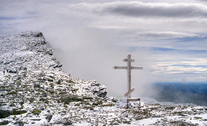
This highest mountain of the Ural Mountains and its surroundings became of interest to fans of extreme sports only in the late 50s of the last century. With the arrival of tourists here, the appearance of the mountain began to change. Various plaques and memorial signs appeared here. Tourists have a custom of leaving notes at the top. And in 1998, the Orthodox Church installed a worship cross here, on which is written “Save and Preserve.” In 1999, Christians went even further; they organized a religious procession to the highest point of the Urals.
Description of Mount Narodnaya
The slopes of this majestic peak are covered with karas - these are natural bowl-shaped depressions that are filled with ice and clear water. In addition, there are many large stone blocks here. There are snowfields and glaciers. The terrain in this part of the Stone Belt is mountainous, with deep gorges and steep cliffs. Tourists must be very careful to avoid injury. Moreover, the nearest housing is very, very far away. You can climb Narodnaya Peak along the western ridge, but there are very rocky steep slopes and a lot of pits, which makes the ascent very difficult. It is easier to climb the northern slope - along the spurs of the mountain. And the eastern side of the peak consists entirely of steep walls and gorges.
Equipment
You don't need any climbing equipment to climb this peak. However, to hike in deserted mountainous areas, you should have high-quality sportswear. And in case of insufficient tourist experience, it is best to use the services of an experienced guide. It must be taken into account that the climate of the subpolar Urals is very harsh. The weather here is cold and changeable even in summer. It is believed that the most favorable period for going to this region is July and the first half of August. When getting ready to go, you should take into account that the trip will last at least a week. There is no housing here, you will only have to spend the night in tents. Geographically, Mount Narodnaya belongs to the Khanty-Mansi Autonomous Okrug. If you are not limited in time, you can visit another point - the top of Managar. It is, of course, lower than Narodnaya, but it will surprise you with its extraordinary beauty.
How to get to the top of Narodnaya?
First you need to travel by rail to the Verkhnyaya Inta station (Komi Republic). Here at the address st. Dzerzhinsky, 27a there is an office of the Yugyd Va National Park. Hikers must register and obtain permission to enter the area. You need to know that the application must be submitted in advance, 10 days before the trip. After completing all the formalities, go to the bus station, from where you will get to the city of Inta. There is a hotel here where you can stay, as it will take some time before you get to the mountain area. To do this, you will need to order a car that will take you to the Zhelannaya industrial base near Lake Bolshoye Balbanty. And from here we walk 17 kilometers to the foot of the mountain along the Balbanyu River. That's it, the rise begins...
I love my native Ural Mountains very much! And that’s why I created a whole section dedicated to this region of Russia. It contains both my personal materials from various hikes in the Ural Mountains, and simply encyclopedic materials about each individual region of the Ural Mountains. This section is a guide to the Ural Mountains and will be very useful for tourists, travelers and simply nature lovers. Sights of the Urals, numerous photographs, description of the region.
The Polar Urals are the northernmost part of the Ural Mountains. The northern border of the region is considered to be Mount Constantine Stone, and in the south the border with the Subpolar Urals is the Lyapin (Khulga) River. Area - about 25,000 km.
The Subpolar Urals is a mountain system in Russia. Its northern border starts from the sources of the Lyapin (Khulga) River 65 40’ N. sh., and in the south the border passes through Mount Telposis 64 s. w. Geographical objects of the Subpolar Urals.
The Northern Urals are part of the Ural Mountains. Starts from Kosvinsky Kamen and the neighboring Konzhakovsky Kamen (59° N) in the south to the northern slopes of the Telposis massif
The Middle Urals are the lowest region of the Ural Mountains, lying between 56° and 59° N. w. The southern border is considered to be Mount Yurma, which lies in the Chelyabinsk region, and the northern border is the Kosvinsky Stone mountain and its neighbor, the Konzhakovsky Stone.
The widest part of the Ural Mountains. It is located on the territory of two states: Russia and Kazakhstan. The southern outskirts of the Southern Urals (Mugodzhary) lie on the territory of the Aktobe region of the Republic of Kazakhstan.
The largest rivers of the Urals. In the Urals there are a large number of rivers suitable for rafting - navigable rivers. The most popular routes along the Ural rivers. Photos, descriptions of the most interesting rivers.
Mansi are the people who make up the indigenous population of the Northern Urals. They are Finno-Ugric people, they are direct descendants of the Hungarians (belong to the Ugric group: Hungarians, Mansi, Khanty).
Walking through the Ural forests, we come across a wide variety of different plants that caught our eye with bright colors. But without a special botanical education, we often do not know at all what kind of plants they are
Hiking to the Dyatlov Pass tract in June 2016. My spontaneous trip to the pass, how it happened. How to get to the Dyatlov Pass by car and on foot? Detailed report.
The trip to the Kvarkush plateau took place on August 12-13, 2014. We approached the ridge from the eastern side, through Severouralsk and the Main Ural Ridge, which lies on the border between the Perm Territory and the Sverdlovsk Region.
This trip to Mount Shunut-Kamen took place in October 2010. The four of us went. The weather turned out to be very good, sunny. However, it was already October - and it was quite cool. There were already frosts.
In June 2011 we went to the main mountain and the main ridge of the Sverdlovsk region - the Konzhakovsky Stone. Konjak is a favorite climbing spot for many tourists both from Yekaterinburg and all over Russia.
Our hike to the Taganay ridge turned out to be quite good. We visited the Otklikny ridge and Mount Kruglitsa. We looked at the South Ural taiga, which has a lot of linden, probably instead of Siberian cedar.
We took a bus to the city of Kachkanar. It was still early morning, or rather even night. We waited until dawn at the bus station. We had no idea how to get to Mount Kachkanar - and so we started asking the bus station workers.
Mount Bolshoi Iremel is located on the border of Bashkiria and the Chelyabinsk region. This happened around the end of July - beginning of August 2011. There were 10 of us, 2 cars.
At the end of August 2011, we managed to escape to the north of our region - to the Main Ural Ridge (GUR). It is located strictly on the border of the Sverdlovsk region with the Perm region and stretches from south to north.
The Ural Mountains are among the oldest mountains in the world. They have a relatively low altitude, the highest point is Mount Narodnaya - only 1895 m above sea level. The low height of such a huge mountain system is determined by the age of the mountains. During their existence, previously high mountains were destroyed, forming heaps of stone placers - kurums. But once upon a time, the Ural Mountains were in no way inferior in their grandeur to some Sayan Mountains or perhaps even to the Himalayas themselves!
The surroundings of the ridges are covered with taiga forests, at altitudes above 800 m the forest-tundra belt begins, at altitudes above 850-900 - tundra. In the Southern Urals, the mountains are covered with steppe and are small in size. In the Far North - tundra. From time immemorial, the tundra areas of the mountain have been an excellent place for walking deer by the local indigenous inhabitants of this region. The mountain tundra belt, suitable for deer walking, reaches the central part of the Northern Urals - the Kvarkush plateau. Below Kvarkush, mountain tundra is relatively rare.
The climate in the mountains is continental, temperate continental. Winter at altitudes above 850-900 meters comes early, snow falls already in September and continues to lie all year in the form of small snow patches even at the height of summer - in July. The open higher elevations are very windy, giving the climate harsher conditions. In summer the sun can warm up to +30-33 degrees, and in winter there are temperatures down to -57 (Burmantovo village, Ivdelsky district).
23.08.2015
Mount Narodnaya is the highest point of the Ural Mountains. Its height is 1895 meters. This geographical fact was established relatively recently. Due to the inaccessibility of the Subpolar region, few scientific expeditions have been made to Mount Narodnaya.
At different times, the highest peaks of the Stone Belt of Eurasia were called the following mountains: Sablyu (1497 meters), Telpos-Iz (1617 meters), Manaragu (1660 meters). In 1924-1928, the North Ural Complex Expedition worked here under the leadership of B.N. Gorodkova. One of her detachments, led by A.N. Aleshkov, in 1927, for the first time walked to the upper reaches of the Narod River. Having examined the height of the mountain using scientific methods already available at that time, they determined its height to be 1870 meters (currently it is measured more precisely - 1895 meters).
It was Aleshkov who gave it the name, but he did not document which syllable the emphasis should fall on. Disputes over stress continued until the publication of the textbook for pedagogical universities by F.N. Malkova and N.A. Gvozdetsky in 1963, in which the emphasis was on the first syllable. Since then, this option has been considered correct, derived from the name of the river starting at the foot of the peak. Although, according to Gorodkov, who spoke out after Aleshkov’s death, it was named in honor of the Russian people, as was customary at that time.
The Ural ranges were formed in the Paleozoic era during the period of the Hercynian folding; later they experienced renewal, and their crystalline rocks came to the surface. They are composed of metamorphic, sedimentary and volcanic rocks, very rich in a variety of minerals and rocks. They form flat-topped ridges with gently stepped western slopes and steep steep eastern slopes.
Narodnaya (Mansi “People-Iz”) on the map of the Urals is located as part of the Research Range of the Subpolar Urals, on the border of the Khanty-Mansi Autonomous Okrug and the Komi Republic, its coordinates are 65° N, 60° E. d. It consists of metamorphic schists and ancient quartzites. Its peak is round and double-headed, and the slopes of the mountain are covered with natural depressions - pits filled with water, glaciers, snowfields, rocky outcrops, mountain tundra, rock ruins.
Since Narodnaya became a place of pilgrimage for tourists, objects like “Vasya was here” appeared here - a bust of Lenin, plaques, memorial signs, a pyramid in which visitors leave their notes, a worship cross with the words “Save and Preserve” written on it, installed on the saddle between two mountain peaks in 1998. The eastern slope of the peak, like the entire Urals, is steep and impassable for tourists. The ascent is carried out along the western slope, which is complicated by punishments, and along the more convenient northern one.
From the peaks there is a view of the surrounding highest peaks of the Subpolar Urals - Sablya, Manaragu, etc. The harsh climate of the Subpolar region, which for so long did not allow one to get close to these highest peaks of the Stone Belt of Russia, forms a diverse and rich flora and fauna here. Here you can find coniferous and mixed forests, subalpine and alpine meadows, alpine and arctic tundra. In the warm season, numerous mosquitoes, gadflies, horseflies and smaller blood-sucking insects - biting midges and midges - appear here.
Dwarf birch trees, blueberries, wild rosemary, bilberry, and short larch are replaced by grasses the size of a person, with the occasional rose radiola. Among the animals there are many inhabitants of the tundra - arctic foxes, deer, partridges, wolves. There are badgers, bears, chipmunks. Only two species of grayling are found in mountain rivers. In the lower reaches of the mountains there are somewhat more river fish.
Mount Narodnaya [VIDEO]
The Ural Mountains are located between the West Siberian and East European Plains. Their area is 781,000 square meters. kilometers. Many travelers dream of getting to this miracle of nature in order to see with their own eyes all the splendor of the famous mountain range. Tourists also want to know the name of the highest peak of the Urals in order to climb it or appreciate the full power of the Urals at the foot of this mountain.
Mount Narodnaya is the highest point of the Urals. Its height is 1895 meters. The mountain is located on the territory of the Khanty-Mansiysk Autonomous Okrug and belongs to the mountain system called the Subpolar Urals.

origin of name
There are two pronunciation options for this name. In the first case, the stress is placed on the first syllable – Narodnaya. The thing is that this mountain is located near the Naroda River, whose name sounds in the Komi language as “Naroda-Iz”.
But during the Soviet era, this name was very consonant with popular communist slogans. At every step they talked about the party and the people, so it was decided to shift the emphasis to the second syllable, making this peak the socialist property of the Soviet people.

Scientific and reference publications indicate different stress options. A 1958 geography textbook gives a name that correlates with the name of the river. And in a book from 1954 there is evidence that “Narodnaya” is the only correct pronunciation.
Modern scientists believe that the emphasis should be on the first syllable. This is the official pronunciation of the name.

History of the summit
In 2016, scientists found that this peak was first marked on maps in 1846 by a Hungarian geographer named Antal Reguli. Antal researched the history of the Mansi peoples, trying to understand the origin of their language. Later, the scientist proved that the Hungarian and Mansi languages have common roots.
Antal Reguli explored the high peak and gave it the original Mansi name Poen-Urr, which translated means “top of the head”.
Five years later, an expedition led by E. Hoffmann was sent to this peak. As a result, data was obtained about the geographical position of the mountain and its features.

For a long time, it was believed in scientific circles that this peak was discovered not by Antal Reguli in the 19th century, but by researcher A. Aleshkov with his expedition in 1927. New data were released only in 2016.
Despite this, Aleshkov's expedition played a very important role. After all, it was he who measured the height of Mount Narodnaya, after which the peak officially became the highest point of the Urals.

It should be noted that when visually assessing the height of mountain peaks, it is difficult to understand which one is higher. Mount Monarga stands out for its size. It was for a long time that it was considered the highest point of the Urals. But after Aleshkov’s research, all data was carefully checked. In scientific works it was indicated that it is not Monarga, but the People's Peak that is the giant mountain. She is 200 meters taller than her neighbor.

Summit climate
Peak Narodnaya is covered with glaciers. It is located in a cold climate zone. Long frosty winters prevail in these parts. The average air temperature during the cold period is -20 degrees Celsius.
Strong snowstorms and freezing rains are frequent visitors to these places. In summer, temperatures rarely rise above 10 degrees.

If you want to conquer the top of the Urals, be prepared for harsh climatic conditions. Even experienced travelers will find it difficult to resist the vagaries of nature. Therefore, it is better to take a reliable guide with you.
The best time to climb the mountain is July and August. During this period there are no snowstorms and the sun is shining.

Geographical position
This giant is located between two mountains, which are named after the famous explorers of the Urals - Didkovsky and Karpinsky. The most picturesque view of Narodnaya opens from the top point of Karpinsky Mountain.
Majestic rocky slopes covered with snow-white glaciers attract the attention of tourists. And the highest point of Mount Narodnaya is shrouded in clouds.

This peak is located in a deserted area. There are no settlements nearby.
Next to the mountain giant is the Blue Lake. Travelers who go hiking in the Urals often set up their camps on the shores of this picturesque body of water. Its height above sea level is quite high - 1133 meters.

Tourism and peak Narodnaya
With the rise of tourism in the second half of the 20th century, the Urals became a destination for many Soviet travelers. Mount Narodnaya was no exception.
Every extreme sports enthusiast deep down dreamed of visiting the highest point of the Ural Mountains. Therefore, over time, memorial plaques began to be placed around the peak. The students tried to record their feat, so they brought souvenirs and flags to the top of the mountain giant.
In 1998, the Russian Church installed an Orthodox cross on the main peak. A year later, a religious procession took place along the slopes.

So from the wild, inhospitable Narodnaya Mountain it turned into a hospitable giant.
“The stone belt of the Russian Land” - this is how the Ural Mountains were called in the old days. Indeed, they seem to be girding Russia, separating the European part from the Asian part. Mountain ranges stretching for more than 2,000 kilometers do not end at the shores of the Arctic Ocean. They only submerge in the water for a short time and then “emerge” - first on the island of Vaygach. And then on the Novaya Zemlya archipelago. Thus, the Urals extends to the pole another 800 kilometers.
The “stone belt” of the Urals is relatively narrow: it does not exceed 200 kilometers, narrowing in places to 50 kilometers or less. These are ancient mountains that arose several hundred million years ago, when fragments of the earth’s crust were welded together with a long, uneven “seam.” Since then, although the ridges have been renewed by upward movements, they have been increasingly destroyed. The highest point of the Urals, Mount Narodnaya, rises only 1895 meters. Peaks beyond 1000 meters are excluded even in the most elevated parts.

Very diverse in height, relief and landscapes, the Ural Mountains are usually divided into several parts. The northernmost, wedged into the waters of the Arctic Ocean, is the Pai-Khoi ridge, the low (300-500 meters) ridges of which are partially immersed in glacial and marine sediments of the surrounding plains.
The Polar Urals are noticeably higher (up to 1300 meters or more). Its relief contains traces of ancient glacial activity: narrow ridges with sharp peaks (karlings); Between them lie wide, deep valleys (troughs), including through ones. Along one of them, the Polar Urals are crossed by a railway going to the city of Labytnangi (on the Ob). In the Subpolar Urals, which are very similar in appearance, the mountains reach their maximum heights.
In the Northern Urals, separate massifs of “stones” stand out, noticeably rising above the surrounding low mountains - Denezhkin Kamen (1492 meters), Konzhakovsky Kamen (1569 meters). Here the longitudinal ridges and the depressions separating them are clearly defined. The rivers are forced to follow them for a long time before they gain the strength to escape from the mountainous country through a narrow gorge. The peaks, unlike the polar ones, are rounded or flat, decorated with steps - mountain terraces. Both the peaks and the slopes are covered with the collapse of large boulders; in some places, remnants in the form of truncated pyramids (locally called tumpas) rise above them.
In the north you can meet the inhabitants of the tundra - reindeer in the forests, bears, wolves, foxes, sables, stoats, lynxes, as well as ungulates (elk, deer, etc.).
Random photos of mountains

Scientists are not always able to determine when people settled in a particular area. The Urals are one such example. Traces of the activity of people who lived here 25-40 thousand years ago are preserved only in deep caves. Several ancient human sites have been found. Northern (“Basic”) was located 175 kilometers from the Arctic Circle.
The Middle Urals can be classified as mountains with a large degree of convention: in this place of the “belt” a noticeable failure has formed. There are only a few isolated gentle hills no higher than 800 meters left. The plateaus of the Cis-Urals, belonging to the Russian Plain, freely “flow” across the main watershed and pass into the Trans-Urals plateau - already within Western Siberia.
Near the Southern Urals, which has a mountainous appearance, parallel ridges reach their maximum width. The peaks rarely overcome the thousand-meter mark (the highest point is Mount Yamantau - 1640 meters); their outlines are soft, the slopes are gentle.
Random photos of mountains
The mountains of the Southern Urals, largely composed of easily soluble rocks, have a karst form of relief - blind valleys, funnels, caves and failures formed by the destruction of arches.
The nature of the Southern Urals differs sharply from the nature of the Northern Urals. In summer, in the dry steppes of the Mugodzhary ridge, the earth warms up to 30-40`C. Even a weak wind raises whirlwinds of dust. The Ural River flows at the foot of the mountains along a long depression in the meridional direction. The valley of this river is almost treeless, the current is calm, although there are rapids.
In the Southern steppes you can find ground squirrels, shrews, snakes and lizards. Rodents (hamsters, field mice) have spread to the plowed lands.
Random photos of mountains

The landscapes of the Urals are diverse, because the chain crosses several natural zones - from the tundra to the steppes. Altitudinal zones are poorly expressed; Only the largest peaks, in their bareness, differ noticeably from the forested foothills. Rather, you can perceive the difference between the slopes. Western, also “European”, are relatively warm and humid. They are inhabited by oaks, maples and other broad-leaved trees, which no longer penetrate the eastern slopes: Siberian and North Asian landscapes dominate here.
Nature seems to confirm man’s decision to draw the border between parts of the world along the Urals.
In the foothills and mountains of the Urals, the subsoil is full of untold riches: copper, iron, nickel, gold, diamonds, platinum, precious stones and gems, coal and rock salt... This is one of the few areas on the planet where mining began five thousand years ago and will exist for a very long time.
GEOLOGICAL AND TECTONIC STRUCTURE OF THE URAL
The Ural Mountains were formed in the area of the Hercynian fold. They are separated from the Russian Platform by the Pre-Ural foredeep, filled with sedimentary strata of the Paleogene: clays, sands, gypsum, limestones.
The oldest rocks of the Urals - Archean and Proterozoic crystalline schists and quartzites - make up its watershed ridge.
To the west of it are folded sedimentary and metamorphic rocks of the Paleozoic: sandstones, shales, limestones and marbles.
In the eastern part of the Urals, igneous rocks of various compositions are widespread among the Paleozoic sedimentary strata. This is associated with the exceptional wealth of the eastern slope of the Urals and Trans-Urals in a variety of ore minerals, precious and semi-precious stones.
CLIMATE OF THE URAL MOUNTAINS
The Urals lie in the depths. continent, located at a great distance from the Atlantic Ocean. This determines the continental nature of its climate. Climatic heterogeneity within the Urals is associated primarily with its large extent from north to south, from the shores of the Barents and Kara seas to the dry steppes of Kazakhstan. As a result, the northern and southern regions of the Urals find themselves in different radiation and circulation conditions and fall into different climatic zones - subarctic (up to the polar slope) and temperate (the rest of the territory).
The mountain belt is narrow, the heights of the ridges are relatively small, so the Urals do not have their own special mountain climate. However, meridionally elongated mountains quite significantly influence circulation processes, playing the role of a barrier to the dominant westerly transport of air masses. Therefore, although the climates of the neighboring plains are repeated in the mountains, but in a slightly modified form. In particular, at any crossing of the Urals in the mountains, a climate of more northern regions is observed than on the adjacent plains of the foothills, i.e., the climatic zones in the mountains are shifted to the south compared to the neighboring plains. Thus, within the Ural mountainous country, changes in climatic conditions are subject to the law of latitudinal zonation and are only somewhat complicated by altitudinal zonation. There is a climate change here from tundra to steppe.
Being an obstacle to the movement of air masses from west to east, the Urals serves as an example of a physical-geographical country where the influence of orography on climate is quite clearly manifested. This impact is primarily manifested in better moisture on the western slope, which is the first to encounter cyclones, and the Cis-Urals. At all crossings of the Urals, the amount of precipitation on the western slopes is 150 - 200 mm more than on the eastern.
The greatest amount of precipitation (over 1000 mm) falls on the western slopes of the Polar, Subpolar and partially Northern Urals. This is due to both the height of the mountains and their position on the main paths of Atlantic cyclones. To the south, the amount of precipitation gradually decreases to 600 - 700 mm, increasing again to 850 mm in the highest part of the Southern Urals. In the southern and southeastern parts of the Urals, as well as in the far north, the annual precipitation is less than 500 - 450 mm. Maximum precipitation occurs during the warm period.
In winter, snow cover sets in in the Urals. Its thickness in the Cis-Ural region is 70 - 90 cm. In the mountains, the snow thickness increases with height, reaching 1.5 - 2 m on the western slopes of the Subpolar and Northern Urals. Snow is especially abundant in the upper part of the forest belt. There is much less snow in the Trans-Urals. In the southern part of the Trans-Urals its thickness does not exceed 30 - 40 cm.
In general, within the Ural mountainous country, the climate varies from harsh and cold in the north to continental and fairly dry in the south. There are noticeable differences in the climate of the mountainous regions, western and eastern foothills. The climate of the Cis-Urals and the western slopes of the rop is, in a number of ways, close to the climate of the eastern regions of the Russian Plain, and the climate of the eastern slopes of the rop and the Trans-Urals is close to the continental climate of Western Siberia.
The rugged terrain of the mountains determines a significant diversity of their local climates. Here, temperatures change with altitude, although not as significant as in the Caucasus. In summer, temperatures drop. For example, in the foothills of the Subpolar Urals, the average July temperature is 12 C, and at altitudes of 1600 - 1800 m - only 3 - 4 "C. In winter, cold air stagnates in the intermountain basins and temperature inversions are observed. As a result, the degree of continental climate in the basins is significantly higher than on mountain ranges.Therefore, mountains of unequal height, slopes of different wind and solar exposure, mountain ranges and intermountain basins differ from each other in their climatic features.
Climatic features and orographic conditions contribute to the development of small forms of modern glaciation in the Polar and Subpolar Urals, between 68 and 64 N latitudes. There are 143 glaciers here, and their total area is just over 28 km2, which indicates the very small size of the glaciers. It is not for nothing that when speaking about modern glaciation of the Urals, the word “glaciers” is usually used. Their main types are steam (2/3 of the total) and leaning (slope) ones. There are Kirov-Hanging and Kirov-Valley. The largest of them are the IGAN glaciers (area 1.25 km2, length 1.8 km) and MSU (area 1.16 km2, length 2.2 km).
The area of distribution of modern glaciation is the highest part of the Urals with the widespread development of ancient glacial cirques and cirques, with the presence of trough valleys and peaked peaks. Relative heights reach 800 - 1000 m. The Alpine type of relief is most typical for ridges lying to the west of the watershed, but cirques and cirques are located mainly on the eastern slopes of these ridges. The greatest amount of precipitation falls on these same ridges, but due to blowing snow and avalanche snow coming from steep slopes, snow accumulates in negative forms of leeward slopes, providing food for modern glaciers, which exist thanks to this at altitudes of 800 - 1200 m, i.e. i.e. below the climatic limit.

WATER RESOURCES
The rivers of the Urals belong to the basins of the Pechora, Volga, Ural and Ob, i.e., the Barents, Caspian and Kara seas, respectively. The amount of river flow in the Urals is much greater than on the adjacent Russian and West Siberian plains. Mountainous terrain, an increase in precipitation, and a decrease in temperature in the mountains favor an increase in runoff, so most of the rivers and streams of the Urals are born in the mountains and flow down their slopes to the west and east, to the plains of the Cis-Urals and Trans-Urals. In the north, the mountains are a watershed between the Pechora and Ob river systems, and to the south, between the basins of the Tobol, which also belongs to the Ob and Kama system, the largest tributary of the Volga. The extreme south of the territory belongs to the Ural River basin, and the watershed shifts to the Trans-Ural plains.
Snow (up to 70% of flow), rain (20 - 30%) and groundwater (usually no more than 20%) take part in feeding rivers. The participation of groundwater in feeding rivers in karst areas increases significantly (up to 40%). An important feature of most rivers of the Urals is the relatively small variability of flow from year to year. The ratio of the runoff of the wettest year to the runoff of the leanest year usually ranges from 1.5 to 3.
Lakes in the Urals are distributed very unevenly. The largest number of them is concentrated in the eastern foothills of the Middle and Southern Urals, where tectonic lakes predominate, in the mountains of the Subpolar and Polar Urals, where tarn lakes are numerous. Suffusion-subsidence lakes are common on the Trans-Ural Plateau, and karst lakes are found in the Cis-Urals. In total, there are more than 6,000 lakes in the Urals, each with an area of more than 1 ra, their total area is over 2,000 km2. Small lakes predominate; there are relatively few large lakes. Only some lakes in the eastern foothills have an area measured in tens of square kilometers: Argazi (101 km2), Uvildy (71 km2), Irtyash (70 km2), Turgoyak (27 km2), etc. In total, more than 60 large lakes with a total of with an area of about 800 km2. All large lakes are of tectonic origin.
The most extensive lakes in terms of water surface are Uvildy and Irtyash.
The deepest are Uvildy, Kisegach, Turgoyak.
The most capacious are Uvildy and Turgoyak.
The cleanest water is in lakes Turgoyak, Zyuratkul, Uvildy (the white disk is visible at a depth of 19.5 m).
In addition to natural reservoirs, in the Urals there are several thousand reservoir ponds, including more than 200 factory ponds, some of which have been preserved since the times of Peter the Great.
The water resources of the rivers and lakes of the Urals are of great importance, primarily as a source of industrial and domestic water supply to numerous cities. The Ural industry consumes a lot of water, especially metallurgical and chemical industries, therefore, despite the seemingly sufficient amount of water, there is not enough water in the Urals. A particularly acute water shortage is observed in the eastern foothills of the Middle and Southern Urals, where the water content of rivers flowing from the mountains is low.
Most of the rivers of the Urals are suitable for timber rafting, but very few are used for navigation. Belaya, Ufa, Vishera, Tobol are partially navigable, and in high water - Tavda with Sosva and Lozva and Tura. The Ural rivers are of interest as a source of hydropower for the construction of small hydroelectric power stations on mountain rivers, but are still little used. Rivers and lakes are wonderful vacation spots.
MINERAL RESOURCES OF THE URAL MOUNTAINS
Among the natural resources of the Urals, a prominent role, of course, belongs to the riches of its subsoil. Deposits of raw ore are of the most important importance among mineral resources, but many of them were discovered a long time ago and have been exploited for a long time, therefore they are largely depleted.
Ural ores are often complex. Iron ores contain impurities of titanium, nickel, chromium, vanadium; in copper - zinc, gold, silver. Most of the ore deposits are located on the eastern slope and in the Trans-Urals, where igneous rocks abound.
The Urals are, first of all, vast iron ore and copper provinces. More than a hundred deposits are known here: iron ore (Vysokaya, Blagodati, Magnitnaya mountains; Bakalskoye, Zigazinskoye, Avzyanskoye, Alapaevskoye, etc.) and titanium-magnetite deposits (Kusinskoye, Pervouralskoye, Kachkanarskoye). There are numerous deposits of copper-pyrite and copper-zinc ores (Karabashskoye, Sibaiskoye, Gaiskoye, Uchalinskoye, Blyava, etc.). Among other non-ferrous and rare metals, there are large deposits of chromium (Saranovskoye, Kempirsayskoye), nickel and cobalt (Verkhneufaleyskoye, Orsko-Khalilovskoye), bauxite (the Red Cap group of deposits), Polunochnoe deposit of manganese ores, etc.
There are very numerous placer and primary deposits of precious metals: gold (Berezovskoye, Nevyanskoye, Kochkarskoye, etc.), platinum (Nizhnetagilskoye, Sysertskoye, Zaozernoye, etc.), silver. Gold deposits in the Urals have been developed since the 18th century.
Among the non-metallic minerals of the Urals, there are deposits of potassium, magnesium and table salts (Verkhnekamskoye, Solikamskoye, Sol-Iletskoye), coal (Vorkuta, Kizelovsky, Chelyabinsk, South Ural basins), oil (Ishimbayskoye). Deposits of asbestos, talc, magnesite, and diamond placers are also known here. In the trough near the western slope of the Ural Mountains, minerals of sedimentary origin are concentrated - oil (Bashkortostan, Perm region), natural gas (Orenburg region).
Mining is accompanied by fragmentation of rocks and air pollution. Rocks extracted from the depths, entering the oxidation zone, enter into various chemical reactions with atmospheric air and water. The products of chemical reactions enter the atmosphere and water bodies, polluting them. Ferrous and non-ferrous metallurgy, the chemical industry and other industries contribute to the pollution of atmospheric air and water bodies, so the state of the environment in the industrial areas of the Urals is of concern. The Urals are the undoubted “leader” among Russian regions in terms of environmental pollution.
GEMS
The term "gems" can be used extremely broadly, but experts prefer a clear classification. The science of gemstones divides them into two types: organic and inorganic.
Organic: Stones are created by animals or plants, for example, amber is fossilized tree resin, and pearls are matured in mollusk shells. Other examples include coral, jet and tortoiseshell. Bones and teeth of land and sea animals were processed and used as material for making brooches, necklaces and figurines.
Inorganic: Durable, naturally occurring minerals with a constant chemical structure. Most gemstones are inorganic, but of the thousands of minerals extracted from the depths of our planet, only about twenty are awarded the high title of "gem" - for their rarity, beauty, durability and strength.
Most gemstones occur in nature in the form of crystals or crystal fragments. To get a closer look at the crystals, just sprinkle a little salt or sugar on a piece of paper and look at them through a magnifying glass. Each grain of salt will look like a small cube, and each grain of sugar will look like a miniature tablet with sharp edges. If the crystals are perfect, all their faces are flat and sparkle with reflected light. These are typical crystalline forms of these substances, and salt is indeed a mineral, and sugar is a substance of plant origin.
Almost all minerals form crystal facets if in nature they had the opportunity to grow in favorable conditions, and in many cases, when purchasing precious stones in the form of raw materials, you can see these facets partially or completely. The edges of crystals are not a random play of nature. They appear only when the internal arrangement of atoms has a certain order, and provide great information about the geometry of this arrangement.
Differences in the arrangement of atoms within crystals cause many differences in their properties, including such as color, hardness, ease of splitting, and others that the hobbyist must take into account when processing stones.
According to the classification of A.E. Fersman and M. Bauer, groups of precious stones are divided into orders or classes (I, II, III) depending on the relative value of the stones combined in them.
Precious stones of the first order: diamond, sapphire, ruby, emerald, alexandrite, chrysoberyl, noble spinel, euclase. These also include pearls - a precious stone of organic origin. Clean, transparent, even, thick stones are highly valued. Poorly colored, cloudy, with cracks and other imperfections, stones of this order may be valued lower than precious stones of the second order.
Precious stones of the second order: topaz, beryl (aquamarine, sparrowite, heliodor), pink tourmaline (rubellite), phenacite, demantoid (Ural chrysolite), amethyst, almandine, pyrope, uvarovite, chrome diopside, zircon (hyacinth, yellow and green zircon), noble opal With exceptional beauty of tone, transparency and size, the listed stones are sometimes valued along with first-order precious stones.
III order gemstones: turquoise, green and polychrome tourmalines, cordierite, spodumene (kunzite), dioptase, epidote, rock crystal, smoky quartz (rauchtopaz), light amethyst, carnelian, heliotrope, chrysoprase, semi-opal, agate, feldspars (sunstone , moonstone), sodalite, prehnite, andalusite, diopside, hematite (bloodstone), pyrite, rutile, amber, jet. Only rare species and specimens have a high cost. Many of them are so-called semi-precious in terms of their use and value.
The Urals have long amazed researchers with the abundance of minerals and its main wealth - minerals. There is so much to be found in the underground storerooms of the Urals! Extraordinary-sized hexagonal rock crystals, amazing amethysts, rubies, sapphires, topazes, wonderful jaspers, red tourmaline, the beauty and pride of the Urals - green emerald, which is valued several times more than gold.
The most “mineral” place in the region is Ilmen, where more than 260 minerals and 70 rocks were discovered. About 20 minerals were discovered here for the first time in the world. The Ilmen Mountains are a real mineralogical museum. Here you can find such precious stones as: sapphire, ruby, diamond, etc., semi-precious stones: amazonite, hyacinth, amethyst, opal, topaz, granite, malachite, corundum, jasper, sun, moon and Arabic stone, rock crystal, etc. .d.
Rock crystal is a colorless, transparent, usually chemically pure, almost impurity-free variety of low-temperature modification of quartz - SiO2, crystallizing in the trigonal system with a hardness of 7 and a density of 2.65 g/cm3. The word “crystal” itself comes from the Greek word “krystallos”, which means “ice”. Scientists of antiquity, starting with Aristotle and including the famous Pliny, were convinced that “in the fierce Alpine winter, ice turns into stone. The sun is then unable to melt such a stone...”. And not only the appearance, but also the ability to always remain cool contributed to the fact that this opinion lasted in science until the end of the 18th century, when the physicist Robert Boyle proved that ice and crystal are completely different substances by measuring the specific gravity of both. The internal structure of ROCK CRYSTAL is often complicated by twin intergrowths, which significantly worsen its piezoelectric homogeneity. Large pure single crystals are rare, mainly in the voids and cracks of metamorphic shales, in the voids of hydrothermal veins of various types, as well as in chamber pegmatites. Homogeneous transparent single crystals are the most valuable technical raw material for optical instruments (spectrograph prisms, lenses for ultraviolet optics, etc.) and piezoelectric products in electrical and radio engineering.
Rock crystal is also used for the manufacture of quartz glass (low-grade raw material), in artistic stone-cutting and for jewelry. Rock crystal deposits in Russia are concentrated mainly in the Urals. The name emerald comes from the Greek smaragdos or green stone. In ancient Rus' it is known as smaragd. Emerald occupies a privileged place among precious stones; it has been known since ancient times and was used both as decoration and in religious rites.
Emerald is a variety of beryl, a silicate of aluminum and beryllium. Emerald crystals belong to the hexagonal system. The emerald owes its green color to chromium ions, which replaced some of the aluminum ions in the crystal lattice. This gemstone is rarely found in the form of flawless crystals; as a rule, emerald crystals are severely damaged. Known and valued since antiquity, it is used for inserts into the most expensive jewelry, usually processed with a step cut, one of the varieties of which is called emerald.
Quite a few very large emeralds are known to have received individual names and have been preserved in their original form, although the largest known weighing 28,200 g, or 141,000 carats, found in Brazil in 1974, as well as one found in South Africa weighing 4,800 g, or 24,000 carats, were sawn and faceted for inserts into jewelry.
In ancient times, emeralds were mined mainly in Egypt, in the mines of Cleopatra. Precious stones from this mine ended up in the treasuries of the richest rulers of the ancient world. It is believed that the Queen of Sheba adored emeralds. There is also a legend that Emperor Nero watched gladiator battles through emerald lenses.
Emeralds of much better quality than the stones from Egypt were found in dark mica schists along with other beryllium minerals - chrysoberyl and phenacite on the eastern slope of the Ural Mountains near the Tokovaya River, approximately 80 km east of Yekaterinburg. The deposit was accidentally discovered by a peasant in 1830, after noticing several green stones among the roots of a fallen tree. Emerald is one of the stones associated with the Supreme Spirit. It is believed that it brings happiness only to a pure but illiterate person. The ancient Arabs believed that a person who wears an emerald does not have terrible dreams. In addition, the stone strengthens the heart, eliminates troubles, has a beneficial effect on vision, and protects against seizures and evil spirits.
In ancient times, emerald was considered a powerful talisman of mothers and sailors. If you look at a stone for a long time, then in it, like in a mirror, you can see everything secret and discover the future. This stone is credited with a connection with the subconscious, the ability to turn dreams into reality, penetrate secret thoughts, and was used as a remedy for poisonous snake bites. It was called the “stone of the mysterious Isis” - the goddess of life and health, the patroness of fertility and motherhood. He acted as a symbol of the beauty of nature. The special protective properties of emerald are an active fight against the deceit and infidelity of its owner. If the stone cannot resist evil qualities, it may break.
DIAMOND is a mineral, a native element, found in the form of eight- and twelve-sided crystals (often with rounded edges) and their parts. Diamond is found not only in the form of crystals, it forms intergrowths and aggregates, among which there are: bead - fine-grained intergrowths, ballas - spherical aggregates, carbonado - very fine-grained black aggregates. The name of the diamond comes from the Greek "adamas" or irresistible, indestructible. The extraordinary properties of this stone have given rise to many legends. The ability to bring good luck is just one of the countless properties attributed to diamonds. Diamond has always been considered the stone of winners; it was the talisman of Julius Caesar, Louis IV and Napoleon. Diamonds first came to Europe in the 5th-6th centuries BC. At the same time, diamond gained its popularity as a precious stone relatively recently, only five hundred and a half years ago, when people learned to cut it. The first semblance of a diamond was owned by Karl the Bold, who simply adored diamonds.
Today, the classic brilliant cut has 57 facets, and provides the famous “game” of the diamond. Usually colorless or painted in pale shades of yellow, brown, gray, green, pink, extremely rarely black. Brightly colored transparent crystals are considered unique, given individual names and described in great detail. Diamond is similar to many colorless minerals - quartz, topaz, zircon, which are often used as its imitations. It is distinguished by its hardness - it is the hardest of natural materials (on the Mohs scale), optical properties, transparency for X-rays, luminosity in X-rays, cathode, ultraviolet rays.
Ruby gets its name from the Latin rubeus, meaning red. The ancient Russian names for the stone are yakhont and carbuncle. The color of rubies varies from deep pink to deep red with a purple tint. The most highly valued among rubies are the “pigeon’s blood” colored stones.
Ruby is a transparent variety of the mineral corundum, an aluminum oxide. The color of ruby is red, bright red, dark red or violet red. The hardness of the ruby is 9, the luster is glassy.
The first information about these beautiful stones dates back to the 4th century BC and is found in Indian and Burmese chronicles. In the Roman Empire, the ruby was extremely revered, and was valued much higher than the diamond. In different centuries, Cleopatra, Messalina and Maria Stuart became connoisseurs of rubies, and the ruby collections of Cardinal Richelieu and Marie de Medici were once famous throughout Europe.
Ruby is recommended for paralysis, anemia, inflammation, fractures and pain in joints and bone tissue, asthma, weakness of the heart, rheumatic heart disease, inflammation of the pericardial sac, inflammation of the middle ear, chronic depression, insomnia, arthritis, diseases of the spine, chronic inflammation of the tonsils, rheumatism. Ruby lowers blood pressure and helps cure psoriasis. Helps with exhaustion of the nervous system, relieves night terrors, helps with epilepsy. Has a tonic effect.
PLANT AND ANIMAL WORLD OF THE URAL
The flora and fauna of the Urals is diverse, but has much in common with the fauna of the neighboring plains. However, mountainous terrain increases this diversity, causing the appearance of altitudinal zones in the Urals and creating differences between the eastern and western slopes.
Glaciation had a great influence on the vegetation of the Urals. Before glaciation, more heat-loving flora grew in the Urals: oak, beech, hornbeam, and hazel. Remains of this flora are preserved only on the western slope of the Southern Urals. As you move south, the altitudinal zonation of the Urals becomes more complex. Gradually, the boundaries of the belts rise higher and higher along the slopes, and in their lower part, when moving to a more southern zone, a new belt appears.
To the south of the Arctic Circle, larch predominates in the forests. As it moves south, it gradually rises along the mountain slopes, forming the upper boundary of the forest belt. Larch is joined by spruce, cedar, and birch. Near Mount Narodnaya, pine and fir are found in the forests. These forests are located mainly on podzolic soils. There are a lot of blueberries in the grass cover of these forests.
The fauna of the Ural taiga is much richer than the fauna of the tundra. Elk, wolverine, sable, squirrel, chipmunk, weasel, flying squirrel, brown bear, reindeer, ermine, and weasel live here. Otters and beavers are found along the river valleys. New valuable animals have been settled in the Urals. The sika deer was successfully acclimatized in the Ilmensky Nature Reserve; muskrat, beaver, deer, muskrat, raccoon dog, American mink, and Barguzin sable were also resettled.
In the Urals, according to differences in altitude and climatic conditions, several parts are distinguished:
Polar Urals. The mountain tundra presents a harsh picture of stone placers - kurums, rocks and outcrops. Plants do not create a continuous cover. Lichens, perennial grasses, and creeping shrubs grow on tundra-gley soils. The fauna is represented by arctic fox, lemming, white owl. Reindeer, white hare, partridge, wolf, ermine, and weasel live in both the tundra and forest zones.
The Subpolar Urals are distinguished by the highest ridge heights. Traces of ancient glaciation are more clearly visible here than in the Polar Urals. On the mountain ridges there are stone seas and mountain tundra, which gives way to mountain taiga lower down the slopes. The southern border of the Subpolar Urals coincides with 640 N latitude. A natural national park has been formed on the western slope of the Subpolar Urals and adjacent areas of the Northern Urals.
The Northern Urals do not have modern glaciers; It is dominated by medium-high mountains, the mountain slopes are covered with taiga.
The Middle Urals are represented by dark coniferous taiga, which is replaced by mixed forests in the south and linden tracts in the southwest. The Middle Urals are the kingdom of mountain taiga. It is covered with dark coniferous spruce and fir forests. Below 500 - 300 m they are replaced by larch and pine, in the undergrowth of which grow rowan, bird cherry, viburnum, elderberry, and honeysuckle.
NATURAL UNIQUES OF THE URAL
Ilmensky ridge. The greatest height is 748 meters, it is unique for the richness of its subsoil. Among the nearly 200 different minerals found here, there are rare and rare ones not found anywhere else in the world. To protect them, a mineralogical reserve was created here back in 1920. Since 1935 this reserve has become comprehensive; now all nature is protected in the Ilmensky Reserve.
The Kungur Ice Cave is a magnificent creation of nature. This is one of the largest caves in our country. It is located on the outskirts of the small industrial city of Kungur, on the right bank of the Sylva River, in the depths of a stone mass - Ice Mountain. The cave has four tiers of passages. It was formed in the thickness of rocks as a result of the activity of groundwater, which dissolved and carried away gypsum and anhydrite. The total length of all 58 surveyed grottoes and transitions between them exceeds 5 km.
Environmental problems: 1) The Urals is a leader in environmental pollution (48% - mercury emissions, 40% - chlorine compounds). 2) Of the 37 polluting cities in Russia, 11 are located in the Urals. 3) Man-made deserts have formed around 20 cities. 4) 1/3 of rivers are devoid of biological life. 5) Every year 1 billion tons of rocks are extracted, of which 80% goes to waste. 6) A special danger is radiation pollution (Chelyabinsk-65 - plutonium production).
CONCLUSION
Mountains are a mysterious and still little known world, uniquely beautiful and full of dangers. Where else can you go from the scorching summer of the desert to the harsh winter of snow in a few hours, hear the roar of a madly roaring stream under the overhanging rocks in a gloomy gorge into which the sun never peeks. Pictures flashing outside the window of a carriage or car will never let you fully feel this formidable splendor...

A week-long tour, one-day hiking and excursions combined with comfort (trekking) in the mountain resort of Khadzhokh (Adygea, Krasnodar Territory). Tourists live at the camp site and visit numerous natural monuments. Rufabgo waterfalls, Lago-Naki plateau, Meshoko gorge, Big Azish cave, Belaya River Canyon, Guam gorge.

